Introduction
Tutorials
Getting familiar with GeoData Manager
Changing how GeoData Manager looks
Scenarios for using GeoData Manager
Data types and nodes
Help with data types and nodes
Getting familiar with GeoData Manager
Changing how GeoData Manager looks
Scenarios for using GeoData Manager
Help with data types and nodes
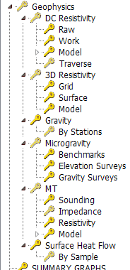
Choose the correct data type category to use depending on the kind of data you want to enter or work with:
| For this kind of data | Choose this category or data type |
|---|---|
| DC resistivity | DC resistivity |
| 3D resistivity | 3D resistivity |
| Gravity | Gravity |
| Microgravity | Microgravity |
| Magnetotellurics (MT) | Magnetotellurics (MT) |
| Surface heat flow | Surface heat flow |
This data type has measured DC Resistivity data (Schlumberger soundings and traverses) and layered models can be stored. Currenly there is no modelling ability within GeoData Manager. However, data can be presented in a range of methods, such as apparent resistivity contouring, and contouring of elevations and thicknesses of selected layers of models from different soundings.
This data type has measured 3D Resistivity data.
This data type has gravity data.
This data type has microgravity data, comprising benchmark definitions, benchmark repeated measurements and gravity repeat measurements.
See here for a tutorial on using MT.
There are six MT nodes:
| Node | Data set |
|---|---|
| MT | This node repeats the node below, Sounding |
| Sounding | The site for a sounding |
| Impedance | Impedance measurements for a sounding |
| Resistivity | Resistivity measurements for a sounding |
| Model | The interpreted 1-D model of resistivity from the above measurements |
| By Layers | As above, Model, but presents the information with all layers in the header data; this is often more convenient for outputting the data |
The interpreted 1-D model has horizontal layers in the ground, and a resistivity for each layer. You can output MT data using Report, Multiple Graph, Map and X-Section.